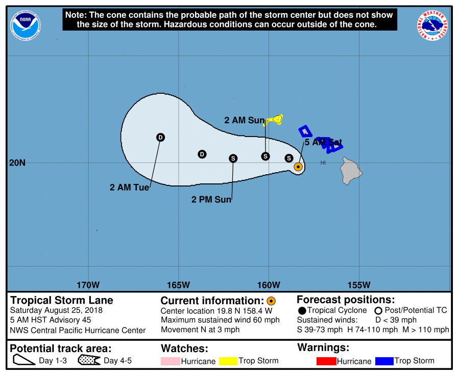
At 500 AM HST (1500 UTC), the center of Tropical Storm Lane was located near latitude 19.8 North, longitude 158.4 West. Lane is moving toward the north near 3 mph (6 km/h), and this motion is expected to continue this morning. This will likely be followed by a turn toward the west with an increase in forward speed starting later today or tonight. This westward motion is forecast to continue through Sunday. On the forecast track, the center of Lane will pass south of Kauai and Niihau later today and tonight.
Maximum sustained winds are near 60 mph (95 km/h) with higher gusts. Some weakening is forecast during the next 48 hours. Tropical-storm-force winds extend outward up to 125 miles (205 km) from the center.
The estimated minimum central pressure is 995 mb (29.39 inches).
HAZARDS AFFECTING LAND
———————-
WIND: Tropical storm conditions are still expected in and near outer rain bands that will affect Oahu and Maui County today. Tropical storm conditions are possible on Kauai starting later today.
RAINFALL: Lane’s outer rain bands will produce excessive rainfall this weekend, which could lead to additional flash flooding and landslides. Lane is expected to produce additional rain accumulations of 5 to 10 inches in some areas. Localized storm total amounts well in excess of 40 inches have already been observed along the windward side of the Big Island.
SURF: Large swells generated by Lane will impact the Hawaiian Islands. These swells will produce high surf along exposed south and east shorelines today.
WATCHES AND WARNINGS
——————–
CHANGES WITH THIS ADVISORY:
The Tropical Storm Warning has been discontinued for Hawaii County.
SUMMARY OF WATCHES AND WARNINGS IN EFFECT:
A Tropical Storm Warning is in effect for…
* Oahu
* Maui County…including the islands of Maui, Lanai, Molokai and Kahoolawe
A Tropical Storm Watch is in effect for…
* Kauai County…including the islands of Kauai and Niihau
A Tropical Storm Warning means that tropical storm conditions are expected somewhere within the warning area.
A Tropical Storm Watch means that tropical storm conditions are
possible within the watch area.
SUMMARY OF 500 AM HST…1500 UTC…INFORMATION
———————————————-
LOCATION…19.8N 158.4W
ABOUT 110 MI…175 KM SSW OF HONOLULU HAWAII
ABOUT 165 MI…265 KM SSE OF LIHUE HAWAII
MAXIMUM SUSTAINED WINDS…60 MPH…95 KM/H
PRESENT MOVEMENT…N OR 350 DEGREES AT 3 MPH…6 KM/H
MINIMUM CENTRAL PRESSURE…995 MB…29.39 INCHES