Hawaii County Civil Defense Tropical Depression 4ET
This is Tropical Depression information update for Wednesday July 8th at 3:30PM.
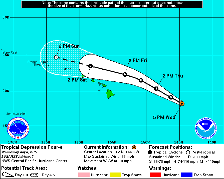
Tropical Depression 4E continues to be monitored and tracked and is currently located approximately 700 miles east of Hilo and moving in a west/northwest direction at 15 miles per hour. The system currently has sustained winds of up to 35 miles per hour with higher gusts. The system has not strengthened throughout the morning and continues to be monitored by the National Weather Service. No watches or warnings are in effect at this time. The community is reminded that hurricane season for Hawaii runs from June through November and everyone is encouraged to plan and prepare for all hazards that pose a threat to our community.
At 5:00 PM HST, the center of
Tropical Depression Four-e
was located at 18.2N 144.6W.
685 miles E of Hilo
750 miles E of Kailua-Kona
730 miles E of South Point
790 miles E SE of Kahului
845 miles E SE of Kaunakakai
820 miles E SE of Lanai City
890 miles E SE of Honolulu
985 miles E SE of Lihue
1035 miles E SE of Niihau
National Weather Service Definitions
Tropical Depression:
A tropical cyclone in which the maximum sustained surface wind speed (using the U.S. 1-minute average) is 33 kt (38 mph or 62 km/hr) or less.
Tropical Storm:
A tropical cyclone in which the maximum sustained surface wind speed (using the U.S. 1-minute average) ranges from 34 kt (39 mph or 63 km/hr) to 63 kt (73 mph or 118 km/hr).
Hurricane / Typhoon:
A tropical cyclone in which the maximum sustained surface wind (using the U.S. 1-minute average) is 64 kt (74 mph or 119 km/hr) or more. The term hurricane is used for Northern Hemisphere tropical cyclones east of the International Dateline to the Greenwich Meridian. The term typhoon is used for Pacific tropical cyclones north of the Equator west of the International Dateline.