Hurricane Hector Advisory Number 26
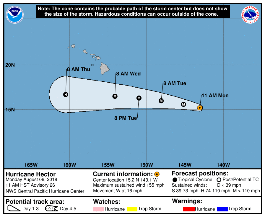
NWS Central Pacific Hurricane Center Honolulu HI   EP102018
1100 AM HST Mon Aug 06 2018

...STRONG CATEGORY FOUR HURRICANE HECTOR CONTINUES TO MOVE
WESTWARD ACROSS THE CENTRAL PACIFIC...
...TROPICAL STORM WATCH ISSUED FOR HAWAII COUNTY...


SUMMARY OF 1100 AM HST...2100 UTC...INFORMATION
-----------------------------------------------
LOCATION...15.2N 143.1W
ABOUT 850 MI...1365 KM ESE OF HILO HAWAII
ABOUT 1055 MI...1700 KM ESE OF HONOLULU HAWAII
MAXIMUM SUSTAINED WINDS...155 MPH...250 KM/H
PRESENT MOVEMENT...W OR 280 DEGREES AT 16 MPH...26 KM/H
MINIMUM CENTRAL PRESSURE...936 MB...27.64 INCHES


WATCHES AND WARNINGS
--------------------
CHANGES WITH THIS ADVISORY:

A Tropical Storm Watch has been issued for...
* Hawaii County

SUMMARY OF WATCHES AND WARNINGS IN EFFECT:
* A Tropical Storm Watch is in effect for...
* Hawaii County

A Tropical Storm Watch means that tropical storm conditions are
possible within the watch area within 48 hours.

Interests elsewhere in the Hawaiian Islands should monitor the
progress of Hector.


DISCUSSION AND OUTLOOK
----------------------
At 1100 AM HST (2100 UTC), the center of Hurricane Hector was
located near latitude 15.2 North, longitude 143.1 West. Hector is
moving toward the west near 16 mph (26 km/h). This general motion
is expected to continue for the next couple of days. On the
forecast track, Hector is expected to pass roughly 150 miles south
of the Big Island of Hawaii on Wednesday.

Maximum sustained winds are near 155 mph (250 km/h) with higher
gusts.  Hector is a category 4 hurricane on the Saffir-Simpson
Hurricane Wind Scale.  Some weakening is forecast during the next 48
hours.

Hurricane-force winds extend outward up to 35 miles (55 km) from the
center and tropical-storm-force winds extend outward up to 105 miles
(165 km).

The estimated minimum central pressure is 936 mb (27.64 inches).


HAZARDS AFFECTING LAND
----------------------
SURF:  Swells generated by Hector are expected to reach southeast
and east facing shores of the Big Island and eastern Maui during
the next day, likely becoming large by late Tuesday and Wednesday.

WIND:  Tropical storm force winds are possible across Hawaii
County on Wednesday.


NEXT ADVISORY
-------------
Next intermediate advisory at 200 PM HST.
Next complete advisory at 500 PM HST.