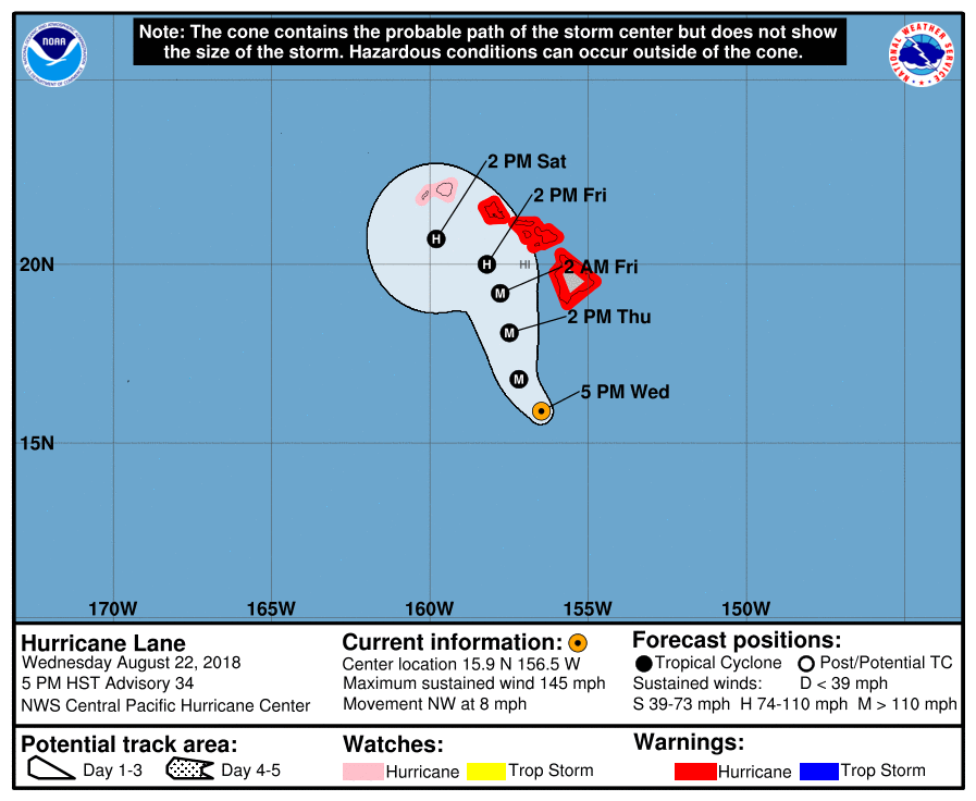
At 500 PM HST (0300 UTC), the eye of Hurricane Lane was located near latitude 15.9 North, longitude 156.5 West. Lane is moving toward the northwest near 8 mph (13 km/h). This motion is expected to continue tonight, with a turn toward the north and a slower forward motion expected on Friday. A turn back toward the west is expected on Saturday. On the forecast track, the center of Lane will move very close to or over the main Hawaiian Islands Thursday and Friday.
Maximum sustained winds are near 145 mph (230 km/h) with higher gusts. Lane is a powerful category 4 hurricane on the Saffir Simpson Hurricane Wind Scale. Some weakening is forecast during the next few days, but Lane is expected to remain a hurricane as it approaches the islands.
Hurricane-force winds extend outward up to 40 miles (65 km) from the center and tropical-storm-force winds extend outward up to 140 miles. (220 km).
SUMMARY OF WATCHES AND WARNINGS IN EFFECT:
A Hurricane Warning is in effect for…
* Oahu
* Maui County…including the islands of Maui, Lanai, Molokai and Kahoolawe
* Hawaii County
HAZARDS AFFECTING LAND
WIND: Tropical storm conditions are expected on portions of the Big Island beginning early Thursday morning, with hurricane conditions expected in some areas Thursday afternoon or Thursday night. Tropical storm conditions are expected to begin over portions of Maui county on Thursday, with hurricane conditions expected in some areas Thursday night into Friday. Tropical storm conditions are expected to begin on Oahu late Thursday night, with hurricane conditions expected Friday.
RAINFALL: Rainbands from Hurricane Lane will continue to gradually overspread the state tonight and Thursday. Excessive rainfall associated with Lane is expected to affect portions of the Hawaiian Islands from late today into the weekend. This could lead to major flash flooding and landslides. Lane is expected to produce total rain accumulations of 10 to 15 inches with localized amounts in excess of 20 inches over the Hawaiian Islands.
SURF: Large swells generated by Lane will impact the Hawaiian Islands, spreading across the island chain tonight and Thursday. These swells will produce very large and potentially damaging surf along exposed west, south and east facing shorelines.
STORM SURGE: The combination of a dangerous storm surge and large breaking waves will raise water levels by as much as 2 to 4 feet above normal tide levels along south and west facing shores near the center of Lane. The surge will be accompanied by large and destructive waves.
For storm information specific to your area, please monitor
products issued by the National Weather Service office in
Honolulu Hawaii.
Keep it tuned to our stations (KWXX, KPUA and B97-B93) for the latest information.