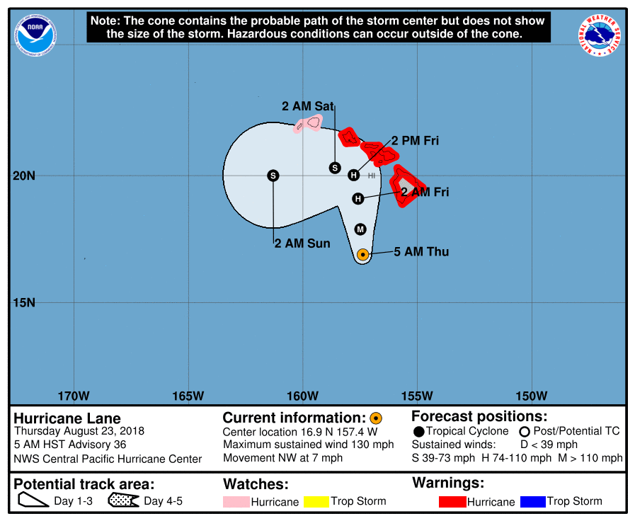
At 500 AM HST (1500 UTC), the center of Hurricane Lane was located near latitude 16.9 North, longitude 157.4 West. Lane is moving toward the northwest near 7 mph (11 km/h). A turn toward the north-northwest and little change in forward speed is expected today. A turn toward the north is anticipated tonight and Friday, as Lane’s forward motion slows. A turn toward the west is expected on Saturday and Sunday, with an increase in forward speed. On the forecast track, the center of Lane will move very close to or over the portions of the main Hawaiian islands later today through Friday.
Maximum sustained winds are near 130 mph (215 km/h) with higher gusts. Lane is a powerful category 4 hurricane on the Saffir Simpson Hurricane Wind Scale. Steady weakening is forecast during the next couple of days. Lane is expected to remain a hurricane as it draws closer to the islands.
Hurricane-force winds extend outward up to 35 miles (55 km) from the center and tropical-storm-force winds extend outward up to 140 miles (220 km). NOAA buoy 51002 located about 250 miles southwest of the Big Island recently reported sustained winds of 50 mph (80 km/h) and a gust of 64 mph (104 km/h).
SUMMARY OF WATCHES AND WARNINGS IN EFFECT:
A Hurricane Warning is in effect for…
* Oahu
* Maui County…including the islands of Maui, Lanai, Molokai and Kahoolawe
* Hawaii County
A Hurricane Watch is in effect for…
* Kauai County…including the islands of Kauai and Niihau