The Hawaii State Department of Health has now released maps showing where COVID-19 cases are on each island.
On the Big Island, with 15 cases per the State Department of Health and 17 per Hawaii County Mayor Harry Kim, most of the cases are mapped on the Kona side of the island. The map data is as of Sunday, Mar. 29, and shows the 14 cases where the patient’s location is known.
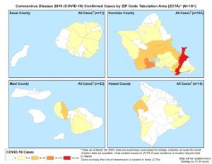
Department of Health stresses that the risk of transmission of COVID-19 is NOT limited to areas where there are more cases. Social distancing, staying 6 or more feet away from others, is proving to be the best way to limit exposure and slow the spread of this virus. Because COVID-19 comes from a novel, or new, coronavirus, that just began spreading to humans around December, people have had no chance to develop immunity and no vaccine is available. So no matter where you are, social distancing, working from home, staying away from others as much as possible, is critical.
The State Department of Health COVID-19 information site updates at noon daily, to reflect the current cases, locations, and information about COVID-19 and how to follow “best practices” to slow the curve on the island and in the state.