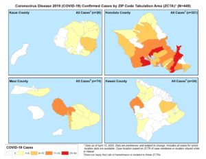
The State of Hawaii Department of Health provides a map of the state, showing where the residence of those confirmed to have COVID-19 live or are staying or have stayed, if not permanent residents. State DOH officials stress that this is not related to where the individual may have been exposed to COVID-19. In using the maps, State DOH has repeatedly stressed that no matter where one is on the island or in the state, social distancing and wearing a mask is imperative, if one leaves home.
As of April 13, 2020, State DOH reports that Hawaii Island has had 40 cases (one new reported today, 5 new reported on Sunday). On Monday morning, Hawaii County Mayor Harry Kim reported that 25 people had recovered and been released from State DOH quarantine and monitoring. State DOH does not release the location of those with active cases, and there is no way to determine that from the maps.
As of April 12, 2020, the Kailua-Kona area shows the most cases on the island, between 11 and 20 (darker orange). The Hilo area shows between 6 and 10 cases (gold). Each yellow area indicates there are between 1 and 5 cases. The locations are based on Zip Code Tabulation Areas (ZCTA), which is a census measurement that roughly correlates to zip codes (but are not actual zip code areas).