The Hawaii State Department of Health often does not release information about where the newest COVID-19 cases are on an island, except in special situations. They do publish a map of where all the county’s cases have been….just below is the map reflecting the locations of the residence or place of lodging of all the Big Island’s confirmed 90 victims since the COVID counting began. Note that out of the 90 cases, 4 are currently active as of today:
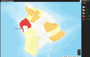
The red area have had 21 to 70 cases, the gold areas have 6 to 10 cases, and the yellow areas have 1 to 5. The white areas have zero.
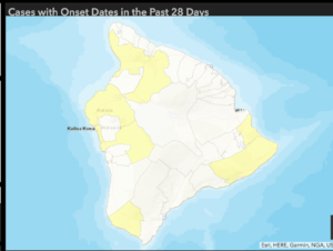
The State DOH also provides a map of where the cases are within the past 28 days. Four weeks ago, the county had 81 cases; today there are 90, with 4 active. The map below shows where the 9 cases confirmed within the last 4 weeks are located, with the yellow areas having 1 to 5 and the white areas having 0.
The State DOH notes that the person’s residence or place of lodging may not be where they were exposed to the novel coronavirus which led to them having COVID-19 and urges everybody to wear a mask in public and practice social isolation to keep COVID-19 under control as much as possible. On the Big Island, the map indicates there are people all around the island who have or have had COVID-19.
The original maps are on the State Department of Health COVID-19 dashboard.