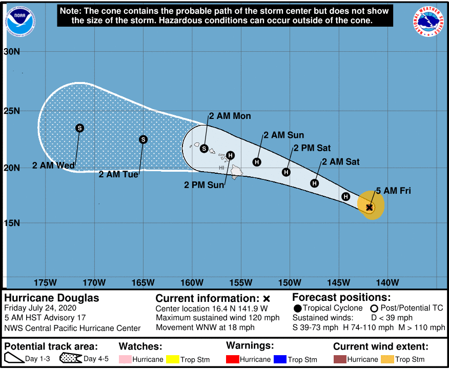
At 500 AM HST, the center of Hurricane Douglas was located near latitude 16.4 North, longitude 141.9 West or 895 miles east-southeast of Hilo. Douglas is moving toward the west-northwest near 18 mph (30 km/h). This motion is expected to continue for the next few days with a gradual decrease in forward speed and a slight turn toward the west. On the forecast track, Douglas will approach the eastern Hawaiian Islands late Saturday night or Sunday.
Maximum sustained winds are near 120 mph (195 km/h) with higher gusts. Douglas is a category 3 hurricane on the Saffir-Simpson Hurricane Wind Scale. Gradual weakening is expected to continue today through the weekend. However, Douglas is still forecast to be near hurricane strength as it approaches the eastern end of the Hawaiian Island chain late Saturday night or Sunday.
Hurricane-force winds extend outward up to 25 miles (35 km) from the center and tropical-storm-force winds extend outward up to 115 miles (185 km).
The estimated minimum central pressure is 962 mb (28.41 inches). We’ll have updates throughout the day on KWXX 94.7FM Hilo / 101.5FM Kona, B97.1FM Hilo / B931.FM Kona, KPUA AM 670 and online on our websites and social media pages. For the latest satellite imagery and weather forecasts visit www.kwxxweather.com.
HAZARDS AFFECTING LAND
———————-
WIND: Strong winds associated with Douglas are expected to affect portions of the Hawaiian Islands as early as late Saturday night or Sunday, through the day Monday. Tropical Storm or Hurricane Watches will likely be required for portions of the state later today.
SURF: Large swells generated by Douglas are expected to begin affecting portions of the Hawaiian Islands on Saturday. These swells are likely to cause life-threatening surf and rip current conditions.
RAINFALL: Heavy rainfall associated with Douglas is expected to affect portions of the Hawaiian Islands from late Saturday night through Monday. Total rain accumulations of 6 to 10 inches with isolated maximum totals of 15 inches will be possible, especially across elevated terrain. This rain may result in life-threatening flash flooding and land slides, as well as rapid water level rises on small streams.