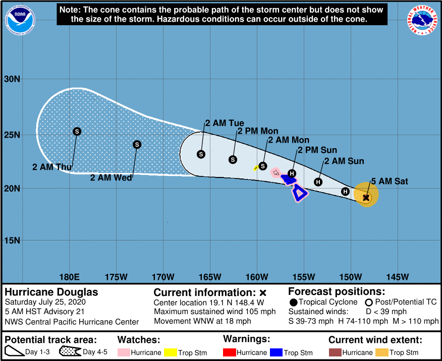
As of 5am Saturday, Hurricane Douglas is still a strong category 2 hurricane with sustained winds near 105 mph with higher gusts. It was located about 440 miles east of Hilo and about 635 east-southeast of Honolulu. Douglas is moving toward the west-northwest near 18 mph. This motion is expected to continue with a slight decrease in forward speed today, followed by a slight turn toward the west tonight through Monday. On the current track, Douglas will be near the main Hawaiian islands later tonight through Sunday night.
The following warnings are now in effect:
A tropical storm warning is now in effect for Hawai’i County, Maui County including the islands of Maui, Lanai, Molokai and Kaho’olawe. A hurricane watch is also in effect for Hawai’i County, Maui County including the islands of Maui, Lanai, Molokai and Kaho’olawe. A tropical storm watch has bee issued for Kauai County including the islands of Kauai and Ni’ihau. A tropical storm warning means tropical storm conditions are expected somewhere within the the warning area within 36 hours, a hurricane watch means that hurricane conditions are possible within the watch area within the next 36-48 hours.
We’ll have updates on air throughout the weekend on KWXX 94.7FM / 101.5 FM B97.1FM Hio, B93.1 FM Kona, KPUA AM 670. Online at www.kwxx.com, www.b97hawaii.com
Download our free apps for iOS and Android to get the latest breaking news and alerts regarding Hurricane Douglas.
Download the KWXX app today:
iOS: https://tinyurl.com/t92j3np
Android: https://tinyurl.com/y3959plt
Download the B97/B93 app today:
iOS- https://tinyurl.com/yyncvv8r
Android – https://tinyurl.com/y4zrox7l
HAZARDS AFFECTING LAND
———————-
WIND: Hurricane conditions are possible across portions of the main Hawaiian Islands late tonight through Sunday night. Tropical Storm conditions are expected across Hawaii County and Maui County beginning late tonight or Sunday. Tropical Storm conditions are possible across Kauai County late Sunday or Sunday night.
SURF: Large swells generated by Douglas are expected to affect the Hawaiian Islands this weekend. These swells are likely to cause life-threatening surf and rip current conditions for the next couple of days.
RAINFALL: Heavy rainfall associated with Douglas is expected to affect portions of the main Hawaiian Islands from late tonight through Monday. Total rain accumulations of 5 to 10 inches are possible from Maui County westward to Kauai County, with the greatest amounts in elevated terrain. This rain may result in life-threatening flash flooding and land slides, as well as rapid water level rises on small streams. Douglas is expected to produce 2 to 5 inches of rainfall over the northern half of the Big Island.