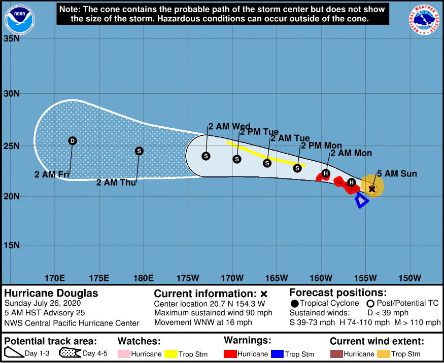
It appears that Hawai’i Island has been spared the brunt of of Hurricane Douglas, however a tropical storm warning remains in effect for the Big Island as some rainy and windy conditions remain. Douglas stills poses a significant threat to much of the State of Hawaii. At 500 AM HST , the center of Hurricane Douglas was located near latitude 20.7 North, longitude 154.3 West. Douglas is moving toward the west-northwest near 16 mph (26 km/h) and this motion is expected to continue over the next couple of days. On the forecast track, Douglas will pass near, or over, the islands from Maui to Kauai today and tonight. It was relative calm and quiet over most of Hawai’i Island in the early morning hours, however some areas in the Kohala district have seen an inch of rain over the last 6 hours. Douglas could produce an additional 2-4 inches of rain over the northern half of Hawai’i Island this morning.
Douglas has maximum sustained winds are near 90 mph (150 km/h) with higher gusts. Gradual weakening is forecast during the next 48 hours, but Douglas is expected to remain a hurricane as it moves through the islands.
Hurricane-force winds extend outward up to 30 miles (45 km) from the center and tropical-storm-force winds extend outward up to 105 miles (165 km).
The estimated minimum central pressure is 983 mb (29.03 inches).
HAZARDS AFFECTING LAND
———————-
WIND: Hurricane conditions are expected in portions of Maui County today, on Oahu by this afternoon, and on Kauai and Niihau tonight. Tropical Storm conditions are imminent across the Big Island. Due to the steep terrain of the islands, hurricane-force wind gusts are possible even within the tropical storm warning area.
SURF: Large swells generated by Douglas will affect the Hawaiian Islands into Monday, producing life-threatening and potentially destructive surf along exposed shores.
STORM SURGE: The combination of higher than predicted water levels, dangerous storm surge, and large breaking waves will raise water levels by as much as 3 feet above normal tides near the center of Douglas.
RAINFALL: Heavy rainfall associated with Douglas is expected to affect portions of the main Hawaiian Islands from early this morning into Monday. Total rain accumulations of 5 to 10 inches are possible from Maui County westward to Kauai County, with the greatest amounts up to 15 inches in elevated terrain. This rain may result in life-threatening flash flooding and land slides, as well as rapid water level rises on small streams. Douglas could produce an additional 2 to 4 inches of rainfall over the northern half of the Big Island.