The State Department of Health has maps on its COVID-19 Dashboard web site that show graphically where cases in the state are located, and where people who are confirmed as having the most recent cases, over the past 28 days, make their homes. The state emphasizes that just because that is where somebody’s home is, that is not necessarily where they contracted the virus.
The total case count for the Big Island as of today is 383. On August 4, 28 days ago, the island had 122 total cases, so the island’s count has increased by 261.
This map shows the cases over the last 28 days, and is courtesy of Ryan Ozawa, an O’ahu tech guru. Any area in white has had zero cases over the past 28 days. Anything in yellow has had up to 25 new cases in the past 28 days. Zip code 96749 (Kea’au/Pahoa) has had 26 to 50 new cases in the past 28 days. Zip code 96720 (Hilo) has had between 51 and 150 cases in the past 28 days.

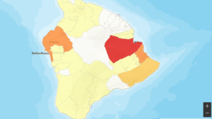
This map, from the State Health site, shows total cases on the island. Anything in white has had zero cases, ever. Anything in yellow has had a total of 1-25 cases. Upper Puna, in goldenrod, has had 26 to 50 total cases. Kailua-Kona and lower Puna, in bronze, have each had between 51 and 150 total cases. Hilo, in red, has had a total of more than 150 cases.