The State Department of Health, without explanation, has changed the way it is displaying the location of new and total COVID-19 cases on maps. And it’s intentionally omitting information for some parts of the Big Island.
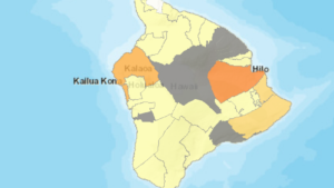
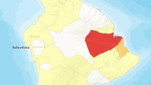
Up until now, the State has used color coding for the entire island, to indicate where cases were anywhere on the island. DOH has been providing various iterations of maps, to show total cases, new cases in the last 28 days, cases per 100,000 people, and more. The map below, dated September 4, from the State Department of Health web site, shows that anyplace in white has had zero new cases in the last 28 days, yellow areas have had 1 to 25 new cases, the goldenrod (lower Puna) indicates 26 to 50 new cases, and the red, Hilo, more than 150 new cases in the last 28 days.
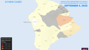
Suddenly, on Saturday, September 5, the State map appearance changed. The scale and colors have changed, but more importantly, there are areas on the map which are now gray. The gray color, according to an email from the State COVID-19 Joint Information Center, are zip codes areas where the population is less than 1,000. The State JIC indicated that no cases will be shown in those areas. This map is new cases within the last 28 days:
This map shows total COVID-19 cases as of Sept. 6, 2020, and is reporting nothing for any area in gray: