Due to a number of recent earthquakes and activity on Kīlauea, scientists have been paying close attention to Mauna Loa. So much so that the USGS has released a map containing estimated response times lava could reach populated areas in the event of an eruption in addition to releasing a number of preparedness tips.
Mauna Loa is the world’s largest active volcano. People residing on its flanks are susceptible to a number of hazards including lava flow, vog, earthquakes and tsunami threats. During its most recent eruption in 1984, lava flow approached the city of Hilo. According to the U.S. Geological Survey, over the past 3,000 years Mauna Loa has erupted lava flows, on average, every 6 years. All historically recorded Mauna Loa eruptions started in the summit area, and approximately half stayed in the summit. Seventeen continued from vents in the volcano’s rift zones, producing lava flows that covered broad areas on the lower slopes of the volcano. Seven flows from the southwest rift zone reached the ocean along the west coast of Hawai‘i within a matter of hours.
The map below outlines estimated response times Big Island residents can expect if Mauna Loa were to erupt. Data for this map was based on Mauna Loa eruptions over the past 200 years. The map includes areas surrounding Mauna Loa color coded by how quickly lava flows can reach populated areas. The warmer the color, the more quickly the flows travel. Mauna Loa lava flows over the past 200 years are shown in gray, and the numbers along the coastline indicate lava travel times to the ocean after the vent(s) opened. Large, bold numbers record the average effusion rates for the different parts of the volcano in millions of cubic meters per day (Mm3/d).
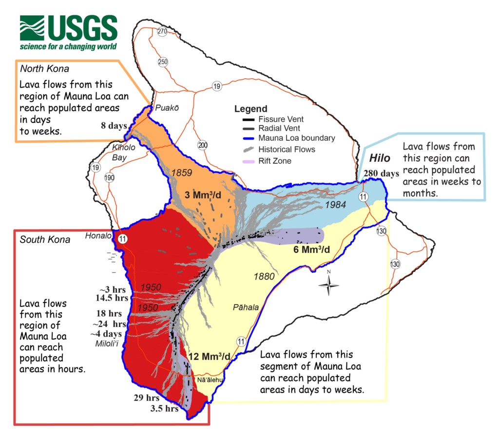
The Hilo area is in blue which means lava traversing the northeast portion of the volcano travels at a modest clip. In the past Mauna Loa flows reached Hilo in weeks to months due to greater distances of populated areas and gentle slopes in the uplands that slow down flow advance.
The southeast flank of the Mauna Loa is in yellow which indicates flows travel at a moderate clip and can reach populated areas in days to weeks. This flank has steep to moderate slopes. In 1880, an ‘a‘ā flow traversed 20 km (16 miles) in 7 days as it advanced toward Kīlauea.
Mauna Loa’s northwest flank is orange which means lava flows can reach populated areas in days to weeks. This flank has moderate to steep slopes and flows travel at a moderate clip. Radial vents in this region in the past issued lava from below sea level to the summit of the volcano. This region is orange because if a radial vent eruption starts low on the flanks, precious little time may be available for response efforts.
The west side of Mauna Loa’s Southwest Rift Zone (SWRZ) is red which means flows can reach populated areas in hours because of the steep slopes and vigorous lava production. Many flows from the SWRZ have entered the ocean in less than a day.
While a Mauna Loa eruption is not imminent, the USGS is encouraging Big Island residents to revisit and/or structure personal response plans including developing an emergency plan with their families, educating themselves about volcano hazards and constructing “go” bags containing essential items that can be quickly accessed in case of emergency evacuation. “Go” bags should contain essential items including important documents like birth certificates and passports, water, non-perishable foods and more. An example “go” back checklist can be found here: https://dod.hawaii.gov/hiema/files/2016/03/GoBagFlyer.pdf.
The USGS Hawaiian Volcano Observatory (HVO) website has additional information on lava flows and other volcanic hazards, including a Mauna Loa fact sheet.
Mauna Loa is not currently erupting and remains at Volcano Alert Level ADVISORY. Eruptions are an inevitable part of Mauna Loa’s future, and risk will continue to grow as population and development increase.