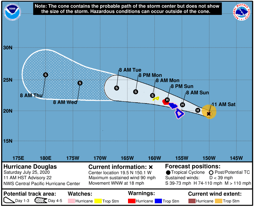
At 1100 AM HST, the eye of Hurricane Douglas was located near latitude 19.5 North, longitude 150.1 West or 325 miles east of Hilo. Douglas is moving toward the west-northwest near 18 mph (30 km/h). This motion is expected to continue through the next couple of days, with a slight decrease in forward speed today. On the forecast track, Douglas will be near the main Hawaiian Islands late tonight and will move over parts of the state Sunday and Monday. While the current forecast track shows Douglas passing slightly to the northeast of Hawai’i Island, forecasters expect Tropical Storm conditions are expected across Hawaii County and Maui County beginning late tonight or Sunday and there is still the potential for Hurricane conditions on Hawai’i Island.
Maximum sustained winds are near 90 mph (150 km/h) with higher gusts. Gradual weakening is expected through the weekend. However, Douglas is still forecast to be near hurricane strength when it nears the islands.
Hurricane-force winds extend outward up to 30 miles (45 km) from the center and tropical-storm-force winds extend outward up to 110 miles (175 km).
The following watches and warnings are now in effect for Hawai’i Island:
Hurricane Watch, Tropical Storm Warning, High Surf Warning, Flash Flood Watch.
A tropical storm warning and hurricane watch are in effect for Maui County including the islands of Maui, Lanai, Molokai and Kaho’olawe and a Hurricane Warning has been issued for O’ahu.
A tropical storm warning means tropical storm conditions are expected somewhere within the the warning area within 36 hours, a hurricane watch means that hurricane conditions are possible within the watch area within the next 36-48 hours.
We’ll have updates on air throughout the weekend on KWXX 94.7FM / 101.5 FM B97.1FM Hio, B93.1 FM Kona, KPUA AM 670. Online at www.kwxx.com, www.b97hawaii.com
Download our free apps for iOS and Android to get the latest breaking news and alerts regarding Hurricane Douglas.
Download the KWXX app today:
iOS: https://tinyurl.com/t92j3np
Android: https://tinyurl.com/y3959plt
Download the B97/B93 app today:
iOS- https://tinyurl.com/yyncvv8r
Android – https://tinyurl.com/y4zrox7l
HAZARDS AFFECTING LAND
———————-
WIND: Hurricane conditions are expected on Oahu on Sunday and Sunday night and are possible across Maui County and the Big Island
late tonight and Sunday. Tropical Storm conditions are expected across Hawaii County and Maui County beginning late tonight or Sunday. Tropical Storm conditions are possible across Kauai County late Sunday.
SURF: Large swells generated by Douglas are expected to affect the Hawaiian Islands during the next couple of days, and storm surge of 2 to 4 feet above normal tides is expected near the center of Douglas. The large swells and surge will produce life threatening and potentially destructive surf along exposed shores.
RAINFALL: Heavy rainfall associated with Douglas is expected to affect portions of the main Hawaiian Islands from late tonight through Monday. Total rain accumulations of 5 to 10 inches are possible from Maui County westward to Kauai County, with the greatest amounts in elevated terrain. This rain may result in life-threatening flash flooding and land slides, as well as rapid water level rises on small streams. Douglas is expected to produce 2 to 5 inches of rainfall over the northern half of the Big Island.